 EMODnet Product Catalogue
Portuguese continental shelf
Type of resources
Available actions
Topics
Keywords
Contact for the resource
Provided by
Years
Formats
Representation types
Update frequencies
status
Scale 1:
-
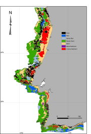
Simplified map of the superficial sediments of the Portuguese continental shelf, based on available information of marine charts and various surveys.Preliminary map preparation involved scanning, georeferencing and digitizing of pre-existing base maps from the Portuguese Hydrographic Institute and harmonization with other published and non-published cartographic information. Samples of soft bottom shelf sediments from nearly 500 sites, collected in the scope of the MeshAtlantic, RENSUB and ACOSHELF projects, were analyzed for grain-size and total organic matter.
-
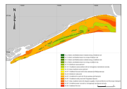
Map based on available information of marine charts and two surveys. Preliminary map preparation involved scanning, georeferencing and digitizing of pre-existing base map from the Portuguese Hydrographic Institute and harmonization with other published and non-published cartographic information. Samples of soft bottom shelf sediments from nearly 100 sites, collected in the scope of the ACOSHELF project, were analyzed for grain-size, total organic matter and macrofaunal comunities.